Our Technologies
From Deep Learning to VR and 3DGS – ExplorerAI powers spatial intelligence.
3D Gaussian Splatting (3DGS)
What it is: 3DGS builds high-fidelity models using “splats”—soft colored points instead of polygons—enabling realistic, fast 3D reconstructions from photos/videos.
How it works: Photos are converted into optimized splats that blend like pointillist art, capturing fine textures and lighting with fewer resources than LiDAR or mesh modeling.
Value: Create digital twins of factories, landmarks, or environments quickly and affordably for VR, simulation, and preservation. See our 3DGS Gallery.
Point Cloud vs 3D Gaussian Splatting (3DGS)
| Category |
Point Cloud |
3DGS |
| Representation | Discrete 3D points | Elliptical Gaussians (position, scale, color, opacity) |
|---|
| Performance | Often slower at very large scales | Fast GPU splatting |
|---|
| File Size | Large (density-dependent) | Compact (optimized primitives) |
|---|
| Detail | Moderate; improves with density | High; smooth continuous surfaces |
|---|
| Visual Quality | Sparser, less photorealistic | More photorealistic, smooth blending |
|---|
| Typical Use | Scanning, measurement, raw capture | Real-time viz, AR/VR, immersive scenes |
|---|
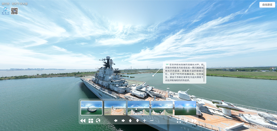
VR Spatial Content Tours
What it is: ExplorerAI creates high-quality 360° tours from real-world panoramic images, GPS coordinates, audio narration, and pop-up information, ideal for culture, education, and marketing.
How it works: Using 360° cameras or stitching techniques, we capture immersive scenes. These are linked into interactive walkthroughs viewable in web or VR headsets, with storytelling layers added.
Value: Enables cultural exploration, remote visits, and sales experiences worldwide. Try it: Travel VR Tour.
Deep Learning for Geo-Analytics
What it is: Advanced AI models that detect and forecast features from aerial imagery—from crop classification to building footprint detection—for agriculture and land management.
How it works: We train neural networks on satellite and drone imagery. These models recognize patterns—distinguishing wheat from corn or healthy vs. drought-affected areas—integrating multiple data sources like IoT and weather.
Value: Our AI predicts yields, monitors environmental changes, and aids property assessment. With 90%+ accuracy, we enable data-driven decisions at regional or national scale.
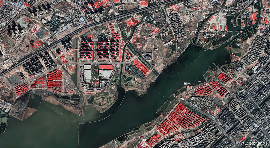
Satellite-based deep learning for crop insights and property analysis.
Applications

Agriculture & Environmental ManagementAI monitors crop health, predicts yield, detects drought, and maps farm zones. Also used for forest loss detection and water resource monitoring.

Property & Land UseAnalyze urban development, illegal construction, and remote surveys. Useful for solar farm monitoring, insurance risk assessment, and infrastructure tracking.

Cultural Tourism & EducationLet people virtually explore cultural heritage, tourist sites, or exhibitions from anywhere. Ideal for schools, tourism boards, and corporate campuses.

Industrial Training & Simulation3D models of factories or plants are used in VR training, safety simulation, or remote inspection. Document construction stages over time.

Architecture & Real Estate MarketingShowcase properties in immersive 3D, scan buildings for restoration, or plan architecture with accurate site references.

Media & EntertainmentUse 3DGS and VR to recreate real places in games, films, or documentaries—blending reality into digital storytelling and the metaverse.
Back to top ↑